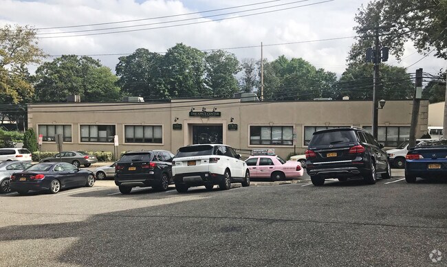
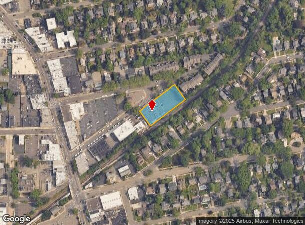
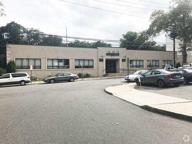
Property Record
50 Maple Pl, Manhasset, NY 11030
NEARBY LISTINGS FOR SALE OR LEASE
Property Detail
50 Maple Pl
2289-03-071-00-0610-0
610-622
Officebuilding
Nassau
X
New York
36059C0112G
610-6
2025
0.63 AC
2025
Western Nassau
301800
Long Island (New York)
24,000 SF
Nassau County-Suffolk County, NY
DEMOGRAPHICS near 50 Maple Pl
1 Mile
3 Mile
5 Mile
2024 Total Population
12,112
112,981
343,657
2029 Population
11,957
111,741
332,907
Pop Growth 2024-2029
(1.28%)
(1.10%)
(3.13%)
Average Age
41
44
44
2024 Total Households
3,925
40,685
121,969
HH Growth 2024-2029
(1.43%)
(1.13%)
(3.41%)
Median Household Inc
$204,482
$138,233
$121,442
Avg Household Size
3.00
2.70
2.70
2024 Avg HH Vehicles
2.00
2.00
2.00
Median Home Value
$1,093,860
$970,776
$814,888
Median Year Built
1947
1956
1955
Nearby Places
- Restaurants
- Banks
- Shops
- Fitness
- Groceries
PUBLIC TRANSPORTATION
TRANSIT/SUBWAY
Manhasset Station (Port Washington Branch - Long Island Rail Road)
DRIVE
WALK
Distance
Manhasset Station (Port Washington Branch - Long Island Rail Road)
1 min
4 min
0.2 mi
COMMUTER RAIL
Manhasset Station (Port Washington Branch - Long Island Rail Road)
DRIVE
WALK
Distance
Manhasset Station (Port Washington Branch - Long Island Rail Road)
1 min
4 min
0.2 mi
Plandome Station (Port Washington Branch - Long Island Rail Road)
DRIVE
WALK
Distance
Plandome Station (Port Washington Branch - Long Island Rail Road)
4 min
1.8 mi
AIRPORT
LaGuardia
DRIVE
WALK
Distance
LaGuardia
24 min
13.7 mi
John F Kennedy International
DRIVE
WALK
Distance
John F Kennedy International
28 min
16.9 mi
Westchester County
DRIVE
WALK
Distance
Westchester County
53 min
32.9 mi
Freight Ports
NY - Red Hook Container Terminal
DRIVE
WALK
Distance
NY - Red Hook Container Terminal
35 min
21.8 mi
Nearby Properties
Address
Land Use
TOTAL SIZE
Lot Size
Zoning
Address
Land Use
TOTAL SIZE
Lot Size
Zoning
356,093 SF
3 AC
R3-2
Address
Land Use
TOTAL SIZE
Lot Size
Zoning
11.30 AC
PARK
Address
Land Use
TOTAL SIZE
Lot Size
Zoning
224,106 SF
6.72 AC
M1-1
Address
Land Use
TOTAL SIZE
Lot Size
Zoning
38,014 SF
1.29 AC
M1-1
Address
Land Use
TOTAL SIZE
Lot Size
Zoning
97,081 SF
2.08 AC
R4
Address
Land Use
TOTAL SIZE
Lot Size
Zoning
45,440 SF
3.15 AC
R3-2
Address
Land Use
TOTAL SIZE
Lot Size
Zoning
5.53 AC
PARK
Address
Land Use
TOTAL SIZE
Lot Size
Zoning
36,400 SF
2.15 AC
R3-1
Address
Land Use
TOTAL SIZE
Lot Size
Zoning
49,638 SF
1.19 AC
R3X
Address
Land Use
TOTAL SIZE
Lot Size
Zoning
16,400 SF
0.57 AC
R1-2
Address
Land Use
TOTAL SIZE
Lot Size
Zoning
39,079 SF
0.51 AC
R3-1
Address
Land Use
TOTAL SIZE
Lot Size
Zoning
18,355 SF
0.39 AC
R3-1
Address
Land Use
TOTAL SIZE
Lot Size
Zoning
26,989 SF
0.83 AC
R1-2
Address
Land Use
TOTAL SIZE
Lot Size
Zoning
35,400 SF
1.06 AC
R2A
Address
Land Use
TOTAL SIZE
Lot Size
Zoning
20,700 SF
0.69 AC
R3X
Address
Land Use
TOTAL SIZE
Lot Size
Zoning
46,411 SF
0.44 AC
R4
Address
Land Use
TOTAL SIZE
Lot Size
Zoning
10,800 SF
0.51 AC
R2A
Address
Land Use
TOTAL SIZE
Lot Size
Zoning
12,542 SF
0.81 AC
R1-2
Address
Land Use
TOTAL SIZE
Lot Size
Zoning
10,414 SF
0.66 AC
R1-2
Address
Land Use
TOTAL SIZE
Lot Size
Zoning
2.34 AC
Address
Land Use
TOTAL SIZE
Lot Size
Zoning
275,334 SF
9.04 AC
Address
Land Use
TOTAL SIZE
Lot Size
Zoning
10,200 SF
0.30 AC
R3-1
Address
Land Use
TOTAL SIZE
Lot Size
Zoning
21,020 SF
0.31 AC
R3-1
Address
Land Use
TOTAL SIZE
Lot Size
Zoning
3,838 SF
1.11 AC
R1-2
Address
Land Use
TOTAL SIZE
Lot Size
Zoning
14,100 SF
0.18 AC
R3-1
Address
Land Use
TOTAL SIZE
Lot Size
Zoning
2,900 SF
0.64 AC
R3-1
Address
Land Use
TOTAL SIZE
Lot Size
Zoning
1.04 AC
R2A
Address
Land Use
TOTAL SIZE
Lot Size
Zoning
9,800 SF
1.72 AC
R2A
Address
Land Use
TOTAL SIZE
Lot Size
Zoning
15,300 SF
0.19 AC
R3-1
Address
Land Use
TOTAL SIZE
Lot Size
Zoning
16,918 SF
0.23 AC
R2A
The World's #1 Commercial Real Estate Marketplace
Connect with us
© 2025 CoStar Group
The information above has been obtained from sources believed reliable. While we do not doubt its accuracy we have not verified it and make no guarantee, warranty or representation about it. It is your responsibility to independently confirm its accuracy and completeness. Any projections, opinions, assumptions, or estimates used are for example only and do not represent the current or future performance of the property. The value of this transaction to you depends on tax and other factors which should be evaluated by your tax, financial, and legal advisors. You and your advisors should conduct a careful, independent investigation of the property to determine to your satisfaction the suitability of the property for your needs.